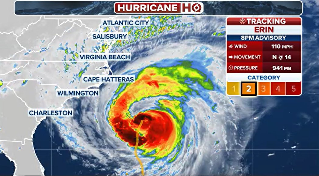
Hurricane Erin, now upgraded to a Category 2 storm, continues its march toward North Carolina’s Outer Banks, and conditions are quickly worsening across the region. The storm, which has prompted evacuation orders and a tropical storm warning, is expected to deliver heavy rain, destructive winds, and storm surge late Wednesday into Thursday.
Officials have stressed that even though Erin may not make direct landfall, it still poses life-threatening risks to residents all along the East Coast. The National Weather Service has warned that hazardous surf, massive waves, and dangerous rip currents will continue to spread northward throughout the week. Already, many popular beaches have banned swimming, with red warning flags seen from Florida to New York, and even New York City officials have closed public beaches to prevent accidents. Local leaders, including North Carolina Governor Josh Stein, have declared a state of emergency and issued strong warnings urging residents to avoid driving through floodwaters or entering the ocean, stressing that storm surge, coastal flooding, and beach erosion will intensify as Erin pushes closer to shore.
By Wednesday evening, parts of North Carolina were already seeing Erin’s outer rainbands sweep across the Outer Banks, bringing high winds and rising seas. Coastal flooding concerns initially eased during low tide, but forecasters noted that impacts would worsen again with the next high tide early Thursday morning. Waves are projected to reach between 10 and 20 feet in some spots, with the Northeast bracing for swells of up to 15 feet. In Buxton, North Carolina, storm surge pushed water beneath the Cape Hatteras Motel, while sections of North Carolina Highway 12—the only road connecting parts of the Outer Banks—were forced to close due to flooding and erosion. Transportation officials pleaded with drivers to stay off submerged roads, repeating the familiar warning: “Turn around, don’t drown.”
Evacuations have already been underway, particularly on Ocracoke Island, where more than 2,000 people have left via ferry following mandatory evacuation orders. Ferry service continues as long as weather conditions allow, but officials say worsening winds and seas may soon make further travel impossible. Hatteras Island residents are also bracing for some of the storm’s worst impacts during high tide, with rescue personnel concerned they may be unable to respond if large waves and surge push water inland.
The impacts of Hurricane Erin are not confined to North Carolina. Experts caution that the storm’s wide wind field will expand through the week, spreading its effects far beyond the Outer Banks. Even several hundred miles offshore, Erin’s power is strong enough to create rip currents and destructive surf along much of the Atlantic coast. The National Oceanic and Atmospheric Administration explains that rip currents can flow outward faster than an Olympic swimmer, dragging unsuspecting swimmers away from the shoreline in seconds. This threat has prompted widespread warnings and closures at beaches across the East Coast, with governors from New Jersey to Florida urging residents and tourists alike to stay out of the water.
Scientists also note that higher average sea levels today compared to past decades have made coastal communities more vulnerable to storms like Erin. Kimberly McKenna, interim director of the Coastal Research Center at Stockton University in New Jersey, explained that sea level rise is intensifying erosion and flooding risks, meaning that even storms that don’t make landfall can cause significant damage to infrastructure and shorelines. Erin’s timing around high tides is also critical—when waves meet elevated water levels, the combined impact can lead to severe flooding and destruction in vulnerable areas.
Forecasts suggest Erin could briefly strengthen into a Category 3 hurricane as it tracks between Bermuda and the U.S. coastline over the next 12 to 24 hours. Even without landfall, the storm is fueling high surf advisories from Florida to Maine. While conditions may begin to improve by late Friday and into Saturday as Erin turns out to sea, officials caution that the coming days will remain dangerous. The East Coast is expected to endure continued beach erosion, flooding, and infrastructure damage as waves batter coastal communities.
Governor Stein summed up the situation bluntly: “North Carolina faces dangerous surf, life-threatening storm surge, flooding, and damage to roadways. No one should take this storm lightly.” With swimming bans, road closures, and evacuations already underway, the message from officials remains clear: residents must prepare for worsening conditions, stay away from the water, and prioritize safety above all else.